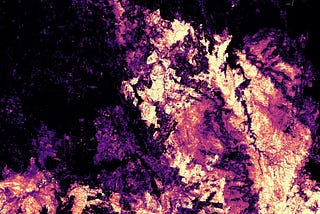
PinnedJBinTowards Data ScienceMapping the 2019–2020 Australian Bushfires with the Open Data CubeAssessing fire extent and fire severity with analysis ready Sentinel-2 data in the Open Date Cube python environment.4 min read·Nov 4, 2020----
JBinTowards Data ScienceOpen Drone Map — Local and Urban Scale Mapping Available to All5 min read·May 6, 2021--1--1
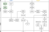
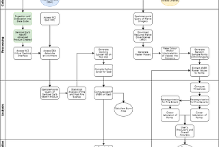
JBinTowards Data ScienceAssessing the Accuracy of Bushfire Severity and Extent MappingAssessing the accuracy of fire severity and extent classifications using Python 3, GeoPandas and ‘normal’ Pandas with data derived from…4 min read·Apr 2, 2021----